Sample pages
Here are some sample pages from the book:
• Contents
Reviews:
• The Guardian (June 2013)
All sample pages and other readings are provided as PDF-files (download a free PDF reader software).
Material

Audio and Video
Danny widely discussed his book in the media. Here is a selection of it:
• Ageing China (Al Jazeera Inside Story, 3rd July 2013, see above) - show online stream
• Today (BBC Radio 4, 20th June 2013) - view as podcast
• Newsday (BBC World Service, 20th June 2013) - view as podcast
• Midori House (Monocle Radio, 21st June 2013) - view as podcast
• Weekend (BBC World Service, 23rd June 2013) - view as podcast
-
•Nightwaves (BBC Radio 3, 20th June 2013) - view as podcast
-
•A global population of 10 billion is nothing to worry about (The Guardian, 14th June 2013)
-
•Some Good News – World Population Day (Huffington Post, 8th July 2013)
Danny has also given many talks and lectures that are related to the subject:
• From cities with no streets to vertical gardens: Audio recording of a lecture at Sheffield University Architecture Society, University of Sheffield, 14th February 2013
• Can the planet support 10 billion people? Audio recording from an invited talk at the Sheffield and Rotherham Green Party AGM, St Mary’s Church, Sheffield, 12th December 2012
• Is more equal more green? Interactive multimedia version of the Monday night lecture at the Royal Geographical Society, London,17 May 2010 (requires Flash player)
More multimedia material can be found on Danny’s website.
Graphics and Visualisations
The original figures from book can be viewed in the Figures section.
The image shown on the Homepage shows the Earth at Night projected on an equal population map that gives every person on the planet an equal amount of map space. It highlights the existing inequalities that become visible in our night skies, with some of the world’s population having poor access to electricity that allows them to pollute the night skies with light. The map has been drawn by Benjamin Hennig and is explained in further detail and shown in high resolution on his website www.viewsoftheworld.net.
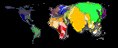
Ben has also created a novel World Population Atlas using the same mapping technique. It shows the countries of the world in their real size and shapes according to the population distribution. It can be accessed on www.worldpopulationatlas.org. The page also gives an overview of the estimated population changes for each country in an interactive population cartogram.